
PADUCAH – The National Weather Service in Paducah says an impactful winter storm will affect our region Tuesday through Wednesday.
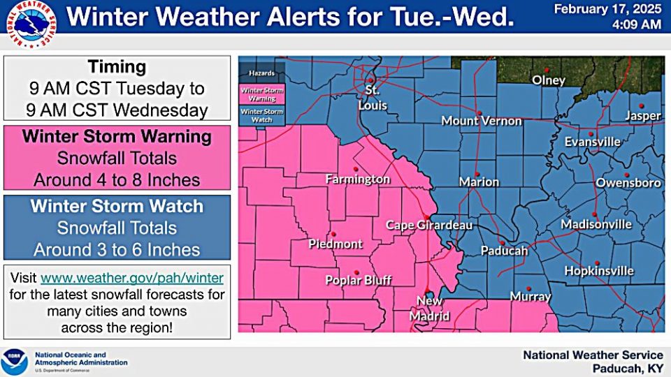
All of southeast Missouri is under a Winter Storm Warning, while the rest of the region remains under a Winter Storm Watch. Several inches of heavy snow and travel impacts are likely.
Derrick Synder, Senior Forecaster at the National Weather Service in Paducah, says the latest snowfall forecast still has significant accumulations Tuesday into Wednesday.
Following the snow, dangerously cold temperatures and wind chills are expected the latter half of the week. Multiple days with lows in the single digits and wind chill values below zero degrees Thursday morning are forecast.
You should delay all travel if possible. If travel is absolutely necessary, drive with extreme caution and be prepared for sudden changes in visibility. Leave plenty of room between you and the motorist ahead of you, and allow extra time to reach your destination. Avoid sudden braking or acceleration, and be especially cautious on hills or when making turns. Make sure your car is winterized and in good working order.
To learn more about how you can prepare for a winter storm and extreme cold, go to https://iemaohs.illinois.gov/.